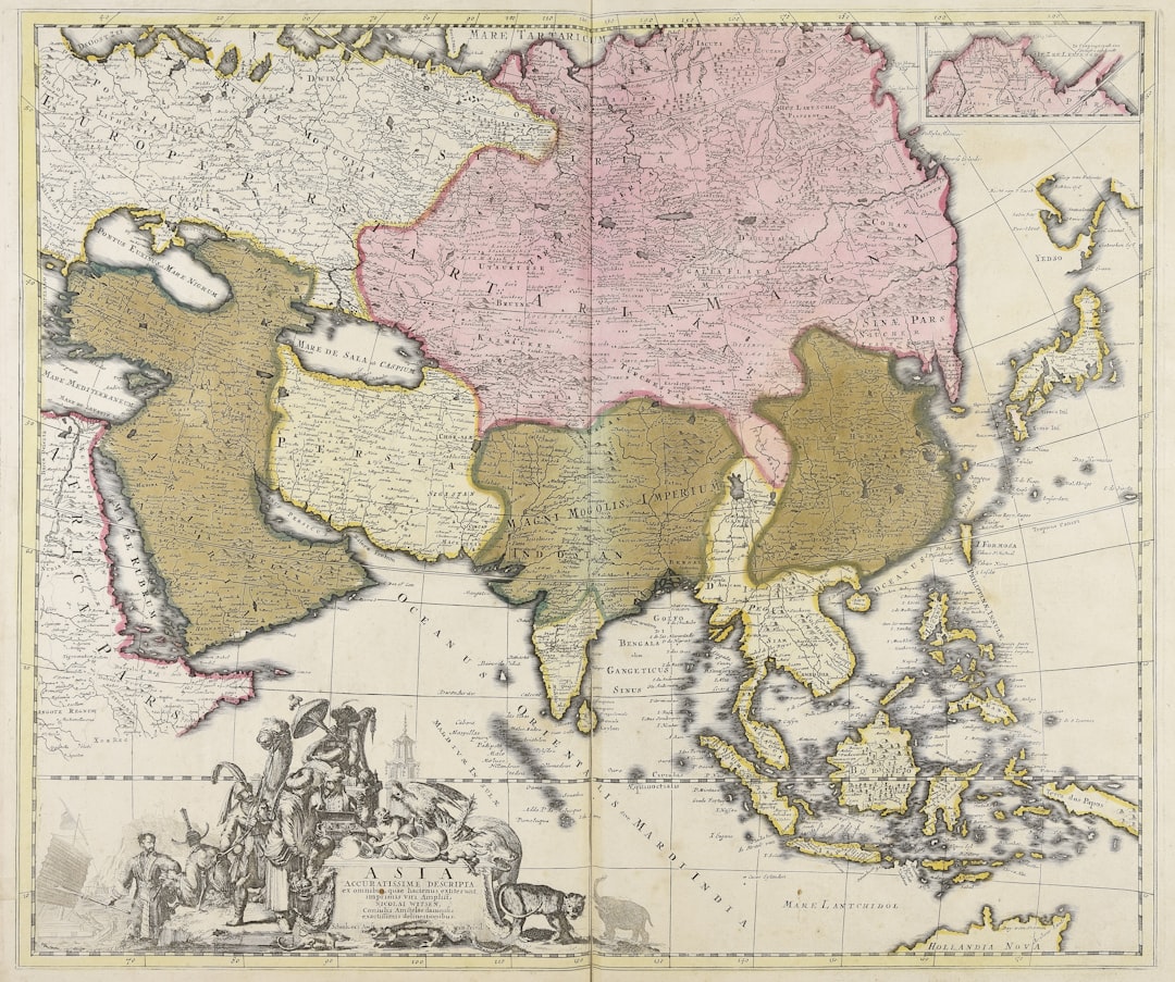
The Piri Reis Map, a world map compiled in 1513 by the Ottoman admiral and cartographer Piri Reis, has long captivated historians, geographers, and enthusiasts of cartographic enigmas. While its depiction of coastlines, particularly those of West Africa, South America, and Antarctica (though the latter remains highly contested, with many scholars attributing the feature to a misidentification or a coincidental landmass), has garnered significant attention, a lesser-explored yet equally intriguing aspect lies within its inland hydrology. The map presents a perplexing network of rivers and other water bodies, particularly in regions that, based on contemporary geographical understanding and historical accounts, appear to be inaccurate or anachronistic. This article delves into the mystery of the Piri Reis Map’s inland hydrology, examining potential explanations and their implications.
The most striking feature concerning the map’s inland hydrology is its rendition of river systems, especially in areas that correspond to South America. While some rivers are recognizable, their placement, course, and confluence points often deviate significantly from reality. It’s as if a cartographer, perhaps working from multiple, disparate sources, attempted to knit together fragments of information without a complete understanding of the whole.
Distortions in South American River Networks
- Amazonian Discrepancies: The Amazon River, a colossal artery of the continent, appears on the Piri Reis Map, but its tributaries and overall network are portrayed with notable inaccuracies. Some rivers are exaggerated in length, while others are entirely omitted or placed in incorrect geographical contexts. One might perceive this as a rudimentary sketch, a first draft of a gargantuan landscape whose true complexity was yet to be fully grasped.
- Missing or Misplaced Rivers: Beyond the Amazon, other significant South American rivers are either absent or depicted in ways that are geographically implausible. This raises questions about the sources Piri Reis consulted and the limitations of the geographical knowledge available to him at the time. Was it a matter of incomplete data, or a cartographic interpretation that stretched the boundaries of accuracy?
The Enigma of Inland Lakes and Tributaries
The map also displays a series of inland lakes and smaller tributaries whose existence and configuration are difficult to reconcile with modern geography. These features, like phantom limbs, suggest an underlying source of information that is either highly archaic or based on speculative accounts.
- Hypothetical Inland Seas: Some scholars have speculated that certain features might represent hypothetical inland seas or large lakes that were once believed to exist but have since been disproven or have significantly receded. This echoes the long-held European belief in the existence of great inland seas in unexplored continents.
- Lost Waterways: Another possibility is that the map depicts waterways that have since dried up, altered their course significantly due to geological processes, or were simply misidentified by earlier explorers. The dynamism of river systems over centuries cannot be underestimated.
The Piri Reis map has long intrigued historians and cartographers due to its detailed depiction of coastlines and landmasses, but its representation of inland hydrology remains a mystery. For those interested in exploring this enigmatic aspect further, a related article can be found at XFile Findings, which delves into the implications of the map’s hydrological features and their significance in understanding ancient geography.
Explanations and Theories: Peeling Back the Layers of Time
The anomalous inland hydrology of the Piri Reis Map has spawned a variety of explanations, each attempting to rationalize these discrepancies. These theories often touch upon the age of the source maps, the geographical knowledge of the era, and the methods of cartographic compilation.
The Role of Ancient Source Maps
One of the most prominent theories posits that Piri Reis compiled his map from a multitude of older charts, some of which may have predated the Age of Exploration. This would explain the presence of features that seem out of place for the early 16th century.
- Pre-Columbian Exploration: The idea that some source maps date back to pre-Columbian exploration of the Americas is a compelling, yet controversial, notion. If such maps existed, their origins and the identities of their creators remain a profound mystery, a whisper from a distant past.
- Survival of Roman or Hellenistic Cartography: Another possibility is the preservation and transmission of ancient cartographic knowledge from Roman or Hellenistic periods. These ancient maps, even if fragmented or distorted over time, could have been incorporated into Piri Reis’s compilation. Imagine a vast library of scrolls, some crumbling, some meticulously preserved, all contributing to a grand, mosaic-like depiction of the world.
The Influence of Oral Traditions and Indigenous Knowledge
Beyond written charts, the influence of oral traditions and indigenous geographical knowledge cannot be entirely discounted. Early explorers and traders would have undoubtedly interacted with native populations, gleaning information about local waterways and terrain.
- Storytelling as Cartography: In many indigenous cultures, oral traditions served as a vital means of transmitting geographical knowledge. These narratives, while not precise in a modern sense, could have conveyed a general understanding of river systems and landforms, which might have then been translated, perhaps imperfectly, onto a map. Think of these stories as threads, spun across generations, sometimes tangling, sometimes revealing surprisingly clear patterns.
- Interpreting Indigenous Descriptions: The challenge lies in how such oral descriptions were interpreted and transcribed by European or Ottoman cartographers. A spoken description of a meandering river with several tributaries could readily become a geometrically stylized representation on a map, losing some fidelity in the process.
Compilation Error and Interpretive Discrepancies
It is equally plausible that some of the inaccuracies stem from the inherent challenges of compiling a world map from disparate and often conflicting sources. Piri Reis himself acknowledged the use of twenty old charts and eight mappae mundi.
- Stitching Together Fragments: Imagine trying to piece together a jigsaw puzzle where many pieces are missing, and others belong to entirely different puzzles. The resulting image, while recognizable in parts, would inevitably contain distortions and misalignments. This is akin to the task faced by Piri Reis.
- Scale and Projection Issues: The differing scales and projections of the various source maps would have presented significant challenges in accurately merging them. In the absence of sophisticated geodetic measurements, rectifying these discrepancies would have been a formidable undertaking.
The North American Enigma: A Speckle of Intrigue
While much attention is given to the South American continent, the Piri Reis Map also presents intriguing, albeit less detailed, hydrological features in what might correspond to North America. These depictions, though rudimentary, add another layer to the map’s hydrological mystery.
The Possibility of Early North American Depictions
- General Outlines of Eastern North America: Some scholars interpret certain landmasses and rudimentary river systems as attempts to depict the eastern coast of North America, possibly including parts of the Great Lakes region or the St. Lawrence River. These are like faint outlines, hints of a landscape yet to be fully explored and charted.
- Challenges of Identification: The vagueness of these northern features makes definitive identification difficult. The absence of clearly recognizable landmarks further complicates efforts to tie these hydrological elements to specific geographical locations.
Shared Source Material with South America?
If these North American features are indeed representations of the continent, it raises the possibility that Piri Reis had access to a broader range of exploratory data, or that some of his “old charts” covered a wider geographical scope than commonly assumed.
- A Continuous Narrative: The presence of both North and South American elements, even if flawed, could suggest a narrative of early exploration that spanned a larger portion of the Western Hemisphere.
- Fragmented Knowledge: More likely, it points to fragmented knowledge, like scattered pieces of a broken mirror, reflecting glimpses of different parts of a vast and still largely unknown land.
Implications and Future Research: Navigating the Uncharted Waters
The enduring mystery of the Piri Reis Map’s inland hydrology continues to provoke scholarly inquiry. Understanding these anomalies has significant implications for our comprehension of early cartography, historical exploration, and the transmission of geographical knowledge across cultures and time.
Re-evaluating Early Exploration Narratives
- Unacknowledged Journeys: If some of the hydrological features indeed stem from older, perhaps pre-Columbian, sources, it could necessitate a re-evaluation of established narratives concerning the earliest explorations of the Americas. This would be like finding a hidden chamber in a well-studied ancient ruin, revealing new perspectives on its history.
- The Reach of Ancient Mariners: It prompts questions about the capabilities and routes of ancient mariners, suggesting a potential for far-reaching voyages that are not fully accounted for in conventional historical records.
The Dynamics of Cartographic Evolution
The Piri Reis Map serves as a powerful testament to the iterative nature of cartography. It is a snapshot of a moment in time, a confluence of centuries of accumulated and often imperfect geographical understanding.
- Layered Knowledge: The map is not a monolithic statement but a layered document, reflecting different eras of knowledge, beliefs, and exploratory efforts. Each river, every lake, is a brushstroke born of diverse hands and varied perspectives.
- The Pursuit of Accuracy: The map, in its imperfections, highlights the relentless human pursuit of accurate geographical representation, a quest that spans millennia and continues to this day.
Leveraging Modern Analytical Techniques
Future research into the Piri Reis Map’s hydrology could significantly benefit from the application of modern analytical techniques.
- Geospatial Analysis: Advanced geospatial analysis tools could be employed to digitally overlay the map’s features onto modern satellite imagery, allowing for a more precise quantification of discrepancies and potential correlations. This would be akin to using a magnifying glass to scrutinize the delicate threads of an ancient tapestry.
- Historical Climatology and Paleogeography: Research in historical climatology and paleogeography could help to determine if past environmental conditions, such as different river courses or the existence of larger lakes, could explain some of the map’s features. The earth itself holds secrets of its past, and these scientific disciplines offer keys to unlock them.
- Digital Reconstruction of Source Maps: Efforts to digitally reconstruct the various hypothetical source maps that Piri Reis might have used could shed light on how these different pieces were integrated and potentially distorted. Imagine a digital archeologist sifting through digital fragments, slowly piecing together the original forms.
In conclusion, the Piri Reis Map’s inland hydrology presents a captivating tangle of geographical inaccuracies, potential ancient knowledge, and the inherent challenges of early cartography. Far from being mere errors, these anomalies are windows into the intellectual landscape of the early 16th century and beyond. They invite us to reconsider the origins of geographical knowledge, the pathways of its transmission, and the remarkable human endeavor to depict and understand the vast and ever-unfolding complexities of our world. As with any great historical puzzle, the Piri Reis Map’s hydrological mystery continues to offer fertile ground for exploration, challenging our assumptions and expanding our understanding of the past.
FAQs
What is the Piri Reis map?
The Piri Reis map is a world map created in 1513 by the Ottoman admiral and cartographer Piri Reis. It is famous for its detailed depiction of parts of the western coasts of Europe, North Africa, and Brazil, as well as some areas of the Atlantic Ocean.
Why is the Piri Reis map considered mysterious?
The map is considered mysterious because it appears to show geographical features, such as coastlines and inland hydrology, with surprising accuracy for its time. Some scholars have debated how Piri Reis could have obtained such detailed information, especially about areas that were not well-explored in the early 16th century.
What does the Piri Reis map reveal about inland hydrology?
The map includes representations of rivers, lakes, and other inland water features, which is unusual for maps of that era. This has led to questions about the sources of Piri Reis’s information and whether he had access to earlier or lost maps that depicted inland hydrological features.
How was the Piri Reis map discovered?
The Piri Reis map was discovered in 1929 in the Topkapi Palace in Istanbul, Turkey. It was found among a collection of Ottoman documents and maps, and it gained international attention due to its unique features and historical significance.
What are some theories about the sources of the Piri Reis map?
Scholars believe that Piri Reis compiled his map using a variety of sources, including earlier maps from the Age of Discovery, charts from Portuguese and Spanish explorers, and possibly ancient maps from Greek or other civilizations. However, the exact sources remain a subject of research and debate.