The study of ancient cartography offers a unique window into the historical understanding of geography, cosmology, and human perception. Through the examination of maps produced across various civilizations and epochs, researchers can discern not only the physical representation of known territories but also the underlying cultural, religious, and scientific frameworks that shaped these depictions. This article delves into the concept of “high altitude perspectives” in ancient maps, exploring how early cartographers grappled with representing a world often known only through ground-level observation, and how their attempts to create a bird’s-eye view predated modern aerial imagery by millennia.
The idea of viewing the Earth from above is not a modern invention, tethered solely to the advent of aircraft or satellite technology. Long before the Wright brothers or Sputnik, ancient civilizations demonstrated a remarkable capacity for conceptualizing a world seen from a vantage point that transcended the human eye-level. This conceptual leap involved abstracting spatial information and translating it onto a two-dimensional surface, a process that demanded considerable intellectual ingenuity.
Early Attempts at Abstraction
The earliest forms of mapping, often etched onto clay tablets or rock faces, were typically topographical, focusing on local features like rivers, mountains, and settlements. These rudimentary maps served practical purposes, such as land demarcations, hunting routes, or military strategies. However, even within these localized depictions, an inherent abstract quality is evident. The act of drawing a river as a line, or a mountain as a triangular shape, is itself an abstract representation of a three-dimensional reality.
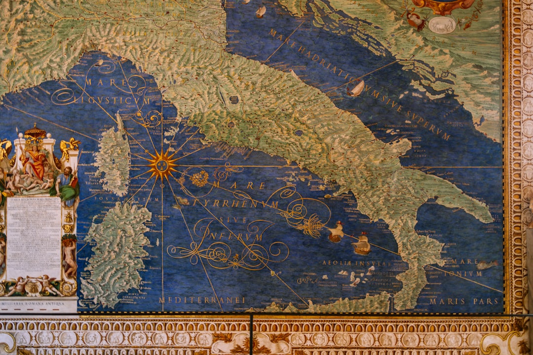
One notable example is the Babylonian Map of the World, dating back to the 6th century BCE. Although highly schematic and symbolic, it attempts to represent the known world, placing Babylon at its center surrounded by a circular ocean and distant lands. While not a “high altitude” map in the literal sense of accurate scaling and projection, it embodies a conceptual “God’s-eye view” – an attempt to encompass the entirety of the perceived cosmos within a single framework. This map, rudimentary as it may seem to modern eyes, serves as a foundational artifact in understanding the human desire to comprehend and delineate the wider world.
Mythological and Cosmological Influences
Early attempts at high-altitude perspectives were often deeply intertwined with mythological and cosmological beliefs. Many ancient cultures envisioned a flat Earth, sometimes supported by giants or animals, protected by a celestial dome. Maps from these periods frequently incorporated these cosmological elements, blending geographical features with mythological narratives. For instance, the Oecumene, or ‘inhabited world’ as understood by classical Greek and Roman geographers, was often depicted as an island surrounded by the great Oceanus, sometimes with specific mythical lands or figures placed at the edges of the known world.
These ancient worldviews were not merely artistic flourishes; they represented the best available knowledge and worldview of their time. The “high altitude perspective” in these cases was not just about physical distance, but also about a cosmic understanding, a perspective from a divine or celestial realm. As you examine these maps, consider them as reflections of a comprehensive worldview, where the earthly and the divine were often inseparable.
Ancient maps have long fascinated historians and cartographers, particularly those that showcase high altitude perspectives, which provide a unique view of geographical features and human settlements. For an in-depth exploration of this topic, you can read the article on ancient cartography and its significance in understanding historical landscapes at XFile Findings. This article delves into the techniques used by ancient mapmakers and how their high-altitude representations influenced navigation and exploration.
Techniques for Representing Distance and Scale
The challenge for ancient cartographers lay in representing vast distances and varying scales without the benefit of modern surveying instruments or mathematical projections. Their solutions were often ingenious, relying on a combination of observation, estimation, and conceptual frameworks.
The Role of Travelers’ Accounts
Much of the geographical information incorporated into ancient maps, particularly for distant lands, was derived from the accounts of travelers, merchants, and conquerors. These narratives, often passed down orally before being recorded, were inherently subjective and prone to inaccuracies. Distances might be measured in “days’ journeys” or “sailing times,” leading to significant distortions when translated onto a map.
Despite these limitations, cartographers attempted to synthesize this disparate information. Imagine a cartographer in Alexandria, attempting to map the Silk Road based on countless caravans’ tales. The resulting map would be a mosaic, a patchwork of verified and speculated geography. This process of integrating qualitative data into a quantitative representation was a precursor to modern data visualization, albeit in a more rudimentary form.
Early Projection Concepts
While formal mathematical projections like Mercator or conic projections are a much later development, ancient mapmakers did employ methods to create a sense of three-dimensionality or an elevated viewpoint. One such technique was the use of perspective drawing, particularly in city plans or detailed local maps where buildings and terrain could be depicted with a rudimentary sense of depth.
Ptolemy’s Geographia, compiled in the 2nd century CE, represents a monumental leap in cartographic science. Ptolemy, building on the work of earlier Greek geographers, understood the need for a systematic projection. He proposed two main projections: a conic projection and a trapezoidal projection, both attempts to translate the spherical Earth onto a flat surface with minimal distortion. While his absolute coordinates were often incorrect due to limitations in measuring longitude, his theoretical framework was revolutionary. He essentially envisioned points on the Earth’s surface as having fixed coordinates, a concept fundamental to any “high altitude” representation. When you look at Ptolemy’s maps, observe the grid lines – these are the foundational scaffolding of what would eventually become global positioning systems.
Regional Variations in High Altitude Mapping

The conceptualization and execution of high altitude perspectives varied significantly across different cultures, reflecting their unique geographical concerns, technological capabilities, and philosophical underpinnings.
The Greco-Roman Tradition: Empiricism and Geometry
The Greco-Roman world, particularly following the Hellenistic period, emphasized empirical observation and geometric principles. As previously mentioned, Ptolemy’s work exemplifies this approach, attempting to create a scientific framework for mapping the world. Their maps, though often lacking in absolute accuracy, strived for a systematic representation of geographical relationships.
The Romans, renowned for their engineering prowess, produced highly practical maps, such as the Tabula Peutingeriana, a surviving copy of an ancient Roman road map. While not a geographically accurate projection of the entire Empire, this scroll-like map provides a linear, high-level perspective of routes and distances, prioritizing connectivity over precise spatial relationships. It is a functional “high altitude” view tailored for travel and logistics, rather than a geopolitical overview. It sacrifices accurate shape and scale for the sake of clear, linear information – a pragmatic abstraction.
Chinese Cartography: Precision and Administrative Control
Ancient Chinese cartography developed independently and often surpassed its Western counterparts in terms of precision and scale for centuries. Drawing on a sophisticated understanding of mathematics and surveying techniques, Chinese cartographers produced remarkably accurate maps, often commissioned by the state for administrative and military purposes.
From the Han Dynasty onwards, Chinese maps employed grid systems and scales, reflecting a systematic approach to land measurement and control. Emperor Yu’s cartographic efforts, as early as the 3rd millennium BCE, are often cited, though direct evidence is scarce. However, later examples like the 1136 CE “Map of China and the Barbarian Countries,” carved into stone, demonstrate astonishing detail and accuracy for regions within China. These maps reveal a “high altitude perspective” born out of a centralized administrative necessity, a desire to effectively govern a vast empire. Imagine the Imperial Court viewing such a map – it was an instrument of power, allowing them to survey their domain from a theoretical aerial vantage point.
Islamic Cartography: Integration and Innovation
During the Islamic Golden Age, Muslim scholars became leading figures in cartography, synthesizing knowledge from Greek, Roman, and Persian traditions, and making significant innovations of their own. They perfected techniques like the astrolabe and further developed mathematical projections.
The work of Muhammad al-Idrisi in the 12th century stands out. His Tabula Rogeriana, produced for King Roger II of Sicily, was one of the most advanced world maps of its time. It incorporated detailed geographical information gathered from extensive travel and research, presenting a relatively accurate depiction of Europe, Africa, and Asia. Al-Idrisi’s maps, often characterized by a south-north orientation, exemplified a “high altitude perspective” that integrated diverse sources of knowledge and applied rigorous scientific methods to their compilation.
The Enduring Legacy of Ancient High Altitude Maps
Even as modern cartography has advanced exponentially with satellite imagery and digital mapping technologies, the efforts of ancient cartographers continue to resonate. Their maps are not merely historical curiosities; they offer invaluable insights into the cognitive processes of early civilizations, their understanding of the world, and their enduring desire to transcend human limitations.
Informing Historical and Archaeological Research
Ancient maps serve as crucial primary sources for historians and archaeologists. They can shed light on ancient trade routes, political boundaries, settlement patterns, and even environmental changes over time. By comparing historical map depictions with archaeological findings, researchers can gain a more complete picture of past societies.
For instance, the precise depiction of features on some ancient Chinese maps has aided in identifying historical sites that might otherwise have been lost to time. Similarly, Roman road maps provide invaluable data for understanding Roman infrastructure and the reach of their empire. These maps, viewed through the lens of modern geographic information systems (GIS), become powerful tools for interdisciplinary research, allowing contemporary scholars to virtually orbit above an ancient landscape the cartographer could only imagine.
A Testament to Human Ingenuity
The creation of ancient high-altitude maps, without the benefit of actual aerial flight, is a profound testament to human ingenuity and the capacity for abstract thought. These maps demonstrate an early understanding of scale, proportion, and the need for systematic representation, laying the groundwork for all subsequent cartographic developments.
Consider the mental leap required to envision an entire continent, or even the known world, as a flattened image that can be comprehended at a glance. This imaginative faculty is what allowed ancient cartographers to synthesize disparate pieces of information – travelers’ tales, astronomical observations, and local surveys – into a coherent whole. Their “high altitude perspectives” were not optical but conceptual, a triumph of the mind over the limitations of direct observation.
Ancient maps have always fascinated historians and cartographers alike, particularly those that offer a high altitude perspective, revealing how civilizations viewed their world. A related article that delves into the intricacies of these maps can be found at XFile Findings, where the significance of aerial views in ancient cartography is explored in detail. These unique representations not only provide insight into geographical knowledge but also reflect the cultural and artistic values of the time.
Future Directions in Studying Ancient Maps
| Map Name | Cartographer | Year | Region Depicted | Altitude Perspective | Notable Features |
|---|---|---|---|---|---|
| Tabula Peutingeriana | Unknown (Roman Empire) | 4th Century AD | Roman Empire Road Network | Bird’s-eye view | Linear schematic map showing roads and cities |
| Hereford Mappa Mundi | Unknown (Medieval England) | c. 1300 | World (Medieval European perspective) | High altitude, symbolic | Religious and mythological elements, Jerusalem at center |
| Fra Mauro World Map | Fra Mauro | 1450 | World | Oblique aerial perspective | Detailed coastal outlines, accurate for its time |
| Da Vinci’s Map of Imola | Leonardo da Vinci | 1502 | Imola, Italy | High altitude, bird’s-eye view | Topographic detail with elevation shading |
| Al-Idrisi’s Tabula Rogeriana | Al-Idrisi | 1154 | Known World (Eurasia and North Africa) | Planar with some altitude cues | South oriented, detailed geographic info |
The field of ancient cartography is continually evolving, with new discoveries and analytical techniques expanding our understanding of these invaluable artifacts.
Digital Reconstruction and Geo-referencing
One of the most promising avenues for future research involves the digital reconstruction and geo-referencing of ancient maps. By employing GIS and other digital tools, researchers can overlay ancient maps onto modern geographical data, allowing for precise comparisons and analyses of accuracy, distortion, and historical changes.
This process involves meticulously aligning historical features with their modern counterparts, a task that often requires significant archaeological and historical expertise. Imagine digitally “flying” over ancient Rome, with the Tabula Peutingeriana overlaid transparently, revealing how a Roman traveler would have perceived their journey in comparison to modern topography. This capability allows scholars to virtually experience the “high altitude perspective” of the ancients, providing a deeper understanding of their spatial cognition.
Uncovering Lost Knowledge and Techniques
Many questions regarding ancient cartographic techniques remain unanswered. Further archaeological excavations and textual analyses may yet reveal new maps or descriptions of mapping methods that could revolutionize our understanding. The discovery of a new papyrus scroll or a detailed inscription could unlock secrets regarding the precision and methodologies employed in lost civilizations.
The ongoing search for the legendary Library of Alexandria, for instance, holds the tantalizing possibility of recovering lost cartographic treatises that could shed light on sophisticated techniques developed millennia ago. The “high altitude perspectives” of the past are not fully known, and there awaits the potential for new discoveries to enrich our comprehension of this profound intellectual journey. Through continued exploration, we can gain new appreciation for the enduring legacy of those who first dared to map the world from an imagined sky.
FAQs
What are ancient maps with high altitude perspective?
Ancient maps with high altitude perspective are historical cartographic representations that depict geographic areas as seen from an elevated viewpoint, often resembling a bird’s-eye view. These maps provide a detailed overview of landscapes, cities, and natural features from above, offering insights into how ancient civilizations visualized their surroundings.
How were high altitude perspectives achieved in ancient maps?
Ancient cartographers used a combination of observation, imagination, and artistic techniques to create high altitude perspectives. Without modern aerial technology, they relied on elevated vantage points such as hills or towers, travelers’ descriptions, and geometric principles to depict terrain and settlements from an elevated angle.
What purposes did ancient high altitude maps serve?
These maps were used for various purposes including navigation, military planning, territorial claims, and religious or ceremonial functions. They helped rulers and travelers understand spatial relationships and the layout of important locations, facilitating governance, trade, and cultural exchange.
Which ancient civilizations are known for producing high altitude perspective maps?
Civilizations such as the Babylonians, Greeks, Romans, Chinese, and medieval Europeans created maps with elevated viewpoints. For example, the Babylonian Imago Mundi and the medieval T-O maps incorporated elements of high altitude perspective to represent the world or specific regions.
How do ancient high altitude maps differ from modern aerial maps?
Ancient high altitude maps were often symbolic and less precise, combining artistic interpretation with geographic information. In contrast, modern aerial maps use satellite imagery and advanced surveying techniques to provide accurate, detailed, and scaled representations of the Earth’s surface from above.