The development of ancient maps began with the earliest human civilizations, driven by practical needs for navigation and territorial documentation. These early cartographic efforts served multiple functions beyond simple wayfinding, including resource management, community organization, and the expression of cultural worldviews. The oldest surviving maps originate from Mesopotamia, dating to approximately 2300 BCE.
These maps were created on clay tablets using cuneiform script and depicted local geographical features including rivers, cities, and surrounding terrain. The Babylonian World Map, dating to the 6th century BCE, represents one of the most significant early attempts to illustrate the known world, showing Babylon at the center surrounded by a circular ocean. Egyptian cartography developed distinct characteristics, incorporating religious and cosmological elements into geographical representations.
Egyptian maps frequently depicted the Nile River and its surrounding regions, reflecting the civilization’s dependence on this waterway. The Turin Papyrus Map, created around 1150 BCE, demonstrates advanced surveying techniques and detailed topographical representation of gold mining areas in the Eastern Desert. Greek contributions to cartography established foundational principles that influenced mapping for centuries.
Anaximander (c. 610-546 BCE) created one of the first world maps based on geometric principles, while Eratosthenes (c. 276-194 BCE) calculated the Earth’s circumference and developed an early coordinate system.
Ptolemy’s “Geographia” (c. 150 CE) provided systematic methods for map projection and established longitude and latitude concepts that remained influential through the medieval period. These Greek innovations emphasized mathematical precision and observational accuracy in cartographic representation.
Key Takeaways
- Ancient maps originated as tools to record and transmit navigational knowledge across generations.
- Navigational memory was crucial for ancient civilizations to explore and connect distant regions.
- Mapmaking techniques evolved from simple sketches to more accurate and detailed representations.
- Cartography played a key role in preserving navigational memory and cultural heritage.
- Ancient maps influenced global exploration, trade routes, and continue to impact modern cartography.
The Importance of Navigational Memory in Ancient Civilizations
Navigational memory played a crucial role in ancient civilizations, serving as a mental map that guided explorers and traders across vast distances. In societies where written language was not yet fully developed, oral traditions became vital for passing down knowledge about routes, landmarks, and seasonal changes. This collective memory allowed communities to navigate their environments effectively, ensuring survival and facilitating trade.
For instance, Polynesian navigators relied heavily on their understanding of the stars, ocean currents, and wind patterns to traverse the Pacific Ocean, demonstrating an intricate relationship between memory and navigation. Moreover, navigational memory was not solely an individual endeavor; it was a communal effort that fostered a sense of identity and belonging among members of a society. As stories of journeys and explorations were shared, they became part of the cultural fabric, reinforcing social bonds and collective knowledge.
In this way, ancient civilizations developed a rich tapestry of navigational lore that transcended generations. The importance of this memory system cannot be overstated; it was essential for trade, exploration, and even warfare, as communities sought to expand their territories and influence.
The Evolution of Mapmaking Techniques in Ancient Times
The evolution of mapmaking techniques in ancient times reflects humanity’s growing understanding of geography and spatial relationships. Early maps were often simplistic, focusing on local features rather than comprehensive representations of larger areas. However, as societies advanced, so did their methods of cartography.
The introduction of more precise tools for measurement, such as the groma in Roman times or the astrolabe in Islamic cultures, allowed for greater accuracy in depicting landscapes. These innovations marked a significant shift from abstract representations to more realistic portrayals of the world. Additionally, the use of symbols and scales became more prevalent as mapmakers sought to convey complex information succinctly.
The Greeks pioneered the use of latitude and longitude, providing a framework that would later be adopted by cartographers around the globe. This mathematical approach to mapping not only improved accuracy but also facilitated communication between different cultures. As trade routes expanded and exploration intensified during the Age of Discovery, the demand for detailed maps surged, leading to further advancements in cartographic techniques that would shape the future of navigation.
The Role of Cartography in Preserving Navigational Memory
Cartography has played an essential role in preserving navigational memory throughout history. As societies transitioned from oral traditions to written records, maps became vital repositories of knowledge that encapsulated centuries of exploration and discovery. They served as visual narratives that documented not only geographical features but also cultural exchanges and historical events.
By creating maps that reflected their understanding of the world, ancient civilizations ensured that their navigational knowledge would endure beyond individual lifetimes. Moreover, cartography acted as a bridge between generations, allowing future explorers to build upon the knowledge of their predecessors. Ancient maps often included annotations and legends that provided context for the depicted landscapes, offering insights into trade routes, territorial boundaries, and even mythological elements.
This layering of information transformed maps into dynamic documents that captured the essence of a civilization’s relationship with its environment. As such, cartography became an indispensable tool for preserving navigational memory and fostering a sense of continuity within cultures.
The Significance of Ancient Maps in Modern Navigation
| Map Name | Origin | Date | Material | Navigation Features | Memory Techniques Used | Significance |
|---|---|---|---|---|---|---|
| Ptolemy’s World Map | Ancient Greece | 2nd Century AD | Parchment | Grid system with latitude and longitude | Geometric referencing | First known use of coordinate system for navigation |
| Tabula Peutingeriana | Roman Empire | 4th Century AD (copy) | Parchment scroll | Road network with distances | Sequential route memory | Used for planning travel routes across the empire |
| Portolan Charts | Mediterranean Europe | 13th-15th Century | Parchment | Compass roses and rhumb lines | Visual landmarks and compass bearings | Enhanced coastal navigation for sailors |
| Medieval Mappa Mundi | Europe | 13th Century | Parchment | Symbolic representation of world geography | Mnemonic storytelling and symbolic imagery | Combined geography with religious and cultural memory |
| Polynesian Stick Charts | Polynesia | Pre-18th Century | Wood and shells | Wave patterns and island positions | Kinesthetic and tactile memory | Used for open ocean navigation without written maps |
The significance of ancient maps extends far beyond their historical context; they continue to influence modern navigation practices today. Many contemporary navigational systems owe their foundations to the principles established by ancient cartographers. The use of coordinates, scales, and symbols can be traced back to early mapping techniques that sought to represent complex geographical information in an accessible manner.
As technology has advanced, these foundational concepts have been adapted to suit modern needs, resulting in sophisticated mapping applications that guide travelers across the globe. Furthermore, ancient maps provide valuable insights into how past civilizations interacted with their environments. By studying these historical documents, modern navigators can gain a deeper understanding of how geographical features have shaped human behavior over time.
This knowledge is particularly relevant in fields such as urban planning and environmental conservation, where understanding historical land use patterns can inform contemporary decision-making processes. Thus, ancient maps serve not only as artifacts but also as living documents that continue to inform and inspire modern navigation.
Uncovering the Secrets of Ancient Mapmaking
Uncovering the secrets of ancient mapmaking involves a multidisciplinary approach that combines archaeology, history, and technology. Researchers have employed various methods to analyze ancient maps, including digital imaging techniques that reveal hidden details and inscriptions. These advancements have allowed scholars to reconstruct lost maps and gain insights into the thought processes behind their creation.
Moreover, studying ancient maps provides a window into the worldview of past civilizations. The symbols used on these maps often reflect cultural beliefs and societal values, offering clues about how people understood their place in the world.
By analyzing these elements, researchers can piece together a more comprehensive picture of how ancient societies navigated both physically and metaphorically through their environments.
The Influence of Ancient Maps on Global Exploration
The influence of ancient maps on global exploration cannot be overstated; they served as both inspiration and guidance for countless explorers throughout history. As European powers began to venture beyond their borders during the Age of Discovery, they relied heavily on earlier cartographic works to navigate uncharted territories. Maps created by ancient civilizations provided crucial information about coastlines, trade routes, and potential hazards—knowledge that was invaluable for those seeking new lands and resources.
Additionally, ancient maps fostered a spirit of curiosity and adventure that propelled explorers to embark on ambitious journeys across oceans and continents. The desire to fill in blank spaces on maps drove individuals like Christopher Columbus and Vasco da Gama to undertake perilous voyages in search of new trade routes and territories. In this way, ancient cartography not only shaped navigation practices but also ignited a passion for exploration that would ultimately transform global dynamics.
How Ancient Maps Helped Shape Trade Routes and Commerce
Ancient maps played a pivotal role in shaping trade routes and commerce by providing essential information about geographical features and resource distribution. As civilizations expanded their networks for trade, accurate maps became indispensable tools for merchants seeking profitable ventures. For instance, the Silk Road—a network of trade routes connecting Asia with Europe—was heavily influenced by cartographic representations that highlighted key cities and resources along the way.
These maps facilitated commerce by enabling traders to plan their journeys strategically. Moreover, ancient maps often depicted not only physical landscapes but also cultural exchanges that occurred along trade routes. They illustrated how goods flowed between different regions and highlighted points where diverse cultures intersected.
This interconnectedness fostered economic growth while also promoting cultural exchange—a phenomenon that continues to shape global commerce today. By studying these historical trade routes through ancient maps, modern scholars can better understand the complexities of economic relationships throughout history.
The Cultural and Historical Significance of Ancient Maps
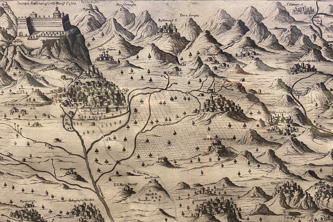
The cultural and historical significance of ancient maps extends beyond their practical applications; they are artifacts that encapsulate the values, beliefs, and aspirations of past civilizations. Each map tells a story—one that reflects not only geographical knowledge but also societal priorities at a given time. For example, maps from ancient China often emphasized harmony with nature and cosmological principles, illustrating how deeply intertwined geography was with philosophical thought.
Furthermore, ancient maps serve as historical documents that provide insights into political boundaries and territorial claims during specific periods. They reveal how empires expanded or contracted over time while also highlighting conflicts over land ownership. By examining these aspects through cartographic lenses, historians can gain a deeper understanding of power dynamics within societies and how they shaped human interactions across regions.
The Legacy of Ancient Maps in Modern Cartography
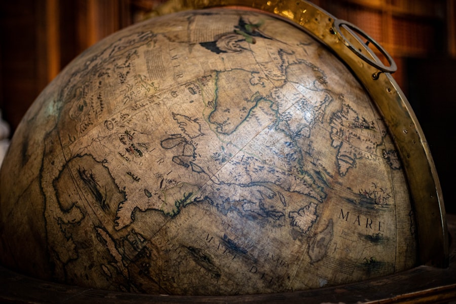
The legacy of ancient maps is evident in modern cartography’s continued evolution; many contemporary mapping practices are rooted in principles established by early cartographers. The emphasis on accuracy, scale representation, and symbol usage can be traced back to ancient techniques that sought to convey complex information effectively. As technology has advanced—from hand-drawn maps to digital mapping applications—the foundational concepts laid by ancient mapmakers remain relevant today.
Moreover, ancient maps inspire modern cartographers to explore new ways of representing spatial information creatively. The artistic elements found in historical maps—such as intricate illustrations or decorative borders—continue to influence contemporary design choices in cartography. This blending of art and science reflects an enduring appreciation for the aesthetic qualities inherent in mapmaking while also emphasizing its practical applications.
Preserving and Studying Ancient Maps for Future Generations
Preserving and studying ancient maps is essential for ensuring that future generations can access this invaluable knowledge. Institutions such as libraries, museums, and universities play a crucial role in safeguarding these artifacts through careful conservation practices that protect them from deterioration over time. Digitization efforts have also gained momentum in recent years; by creating high-resolution digital copies of ancient maps, researchers can make them accessible to a broader audience while minimizing wear on original documents.
In addition to preservation efforts, ongoing research into ancient maps continues to yield new insights into historical geography and cultural interactions. Scholars are increasingly collaborating across disciplines—combining expertise from history, archaeology, geography—to uncover hidden narratives within these artifacts. By fostering interdisciplinary dialogue around ancient cartography’s significance today—both academically and culturally—societies can ensure that this rich legacy endures for generations to come.
In conclusion, ancient maps are more than mere representations of geography; they are windows into the past that reveal humanity’s evolving relationship with its environment. From their origins in early civilizations to their lasting impact on modern navigation practices, these artifacts encapsulate centuries of knowledge and cultural exchange. As societies continue to explore new frontiers—both physically through exploration and digitally through technology—the lessons learned from ancient mapmaking will undoubtedly inform future endeavors while preserving our shared history for posterity.
Navigational memory has long been a fascinating topic, especially when examining how ancient maps influenced the way people understood and interacted with their environments. For a deeper exploration of this subject, you can read the article on ancient cartography and its impact on navigation at XFile Findings. This resource delves into the intricacies of how early maps were created and utilized, shedding light on the cognitive processes involved in navigation during ancient times.
FAQs
What is navigational memory in the context of ancient maps?
Navigational memory refers to the knowledge and techniques used by ancient navigators to remember and interpret routes, landmarks, and geographical features, which were often recorded or represented in ancient maps to aid in travel and exploration.
How were ancient maps used for navigation?
Ancient maps were used as visual tools to represent coastlines, rivers, mountains, and other landmarks. Navigators relied on these maps along with their memory of natural features, celestial bodies, and oral traditions to chart courses and find their way during voyages.
What materials were ancient maps typically made from?
Ancient maps were commonly created on materials such as papyrus, parchment, animal skins, clay tablets, and sometimes carved into stone or wood, depending on the culture and available resources.
Which civilizations are known for their ancient navigational maps?
Civilizations such as the Babylonians, Greeks, Romans, Polynesians, Chinese, and Arabs are known for producing early navigational maps and charts that contributed to maritime exploration and trade.
How accurate were ancient maps compared to modern maps?
Ancient maps varied in accuracy; while some were surprisingly detailed and useful for navigation, many were symbolic or schematic, reflecting the limited geographic knowledge and technology of the time.
What role did oral tradition play in navigational memory?
Oral tradition was crucial in preserving navigational knowledge, including routes, star positions, and landmarks, which were passed down through generations and often complemented the information depicted on maps.
Did ancient navigators use celestial navigation alongside maps?
Yes, ancient navigators frequently used celestial bodies such as the sun, moon, and stars to determine direction and position, combining this knowledge with maps and environmental cues for effective navigation.
How have ancient maps contributed to our understanding of historical geography?
Ancient maps provide valuable insights into how early cultures perceived the world, their trade routes, territorial boundaries, and interactions, helping historians and archaeologists reconstruct past geographies and navigation techniques.
Are any ancient navigational maps still preserved today?
Yes, several ancient maps have been preserved in museums and archives worldwide, including the Babylonian World Map, Ptolemy’s Geographia, and Polynesian stick charts, offering a glimpse into early cartographic and navigational practices.
What is the significance of studying navigational memory and ancient maps today?
Studying navigational memory and ancient maps helps us understand the development of human exploration, the evolution of cartography, and the cultural exchange of geographic knowledge, which laid the foundation for modern navigation and mapping technologies.